Just got back from a short, two day adventure on the Bow Glacier. The avalanche hazard of late has made it impossible to get up in the mountains. After a warm couple of days, avalanches were blasting the mountains with special warnings all over the news. The good news for us was that many of the dangerous slopes were “fixing” themselves by ripping out the dangerous layers. Randy and I spent the last week texting back and forth trying to figure out if we could get up safely to the Bow Glacier. As we watched the changing conditions and weather, we made it a go.
In addition to our own objectives, we were taking some staff from the North Face up to the hut at the foot of the glacier. We spent some extra time doing some avalanche rescue work with them but assessing the avalanche hazards along the way would be up to us. At various points along the way we explained our observations and assessments which we do out loud anyway. I also wanted to try building a snow shelter, and even if I didn’t sleep in it, I thought I would learn a few things about it in an easy, non-emergency situation.
I left Canmore at 6am, picked Randy up and met the others at Bow Lake. We were relieved along the way to see that nearly every steep slope had already avalanched.

Above: Sunrise over Bow Peak is so different every day. The wind had randomly scoured the snow off the lake revealing a black and shiny, marble-like surface that looked like open water from afar. A few from our group were a bit nervous as I skied straight towards what seemed like a hole in the ice. I knew that after the two weeks of -35 over Christmas, the ice was several feet thick. 
Above: Very, very slippery ice made skiing a little difficult but the beauty of the clear ice more than made up for the slower travel time.  Above: Skiin past an unconcerned and invisible Ptarmigan.

Above: A massive chunk of ice calves off the Bow Glacier and avalanches nearly a thousand feet down. Randy and I were waiting for the others as we wanted to lead everyone quickly on the correct line past this face and on to our ascent ramp. Suddenly we watched a bus sized chunk of ice drop. The sound was tremendous. The low roar really vibrated your stomach!
Everyone else saw it too and when they caught up, we had a quick conference explaining that we would be going past this face but well back from the danger zone. Since the slope had already avalanched a few days before, the impact of any ice falling wouldn’t remote trigger an avalanche on the nearby slope we would be climbing. In fact, in this picture, Randy and I are standing on the avalanche debris. Had we been standing here a few days before, the impact of this icefall would have triggered the slope and the avalanche would roll right over where we’re standing. That is why we don’t venture up here when slopes are touchy.
Above: After some hard won elevation gain, Randy drinks in the view of the Crowfoot Glacier. I opened up the Alpine Club hut and got some snow melting for water then went out looking for a place to build my snow shelter. I had previously been reading up on various designs and was anxious to get started.
Above: I picked this spot on the lee side of the drift. After an hour and a half of work, I had a pretty comfortable shelter built. Inside temperature according to my thermometer was a very cozy zero degrees. 
Above: Most sources agree that a smooth, sloping roof is critical to avoiding dripping from above as the space heats. I brought in my sleeping gear and had a half hour nap as a proof of concept and considered it a success as I had learned a few things along the way I would do differently had this been an emergency bivouac.
Above: My “glacier Hilton” even has a nice view!
After spending the night in the hut, I woke at 5:30am, made breakfast and watched the weather. If the visibility was poor, Randy and I were going to depart along with the others back down. If we had a good, clear window, we would make an attempt at a summit. Since we were the only ones with glacier experience, and gear, we would go by ourselves. As Randy got up, the fog was starting to lift a bit but he was exhausted and wanted to go back to bed! Randy is a new father so sleep is not in surplus recently! The previous day, on our final ascent slope, the snow had been polished to an icy hard sheet. I delicately clinged to the slope while I hacked out a ski-width ledge all the way up the final wall so the others could follow without fear of falling to the bottom. As we sat in the morning darkness, we wondered if there was any point in trying to make the thousand foot climb up the glacier if it was going to be a similar sheet of polished glass?
I suggested we harness up, put our glacier gear on, rope up and check it out. If we couldn’t easily climb, then we would just turn around. Our goal for now would be Mt Gordon, the highest mountain around here.
Above: As light breaks, we first check out the glacier with a probe to test the thickness of the crevasse bridges. Randy reports over two meters of very dense snow meaning the crevasses are bridged very solidly. We stay roped up here anyway. I lead us best as I can looking for the lowest angle possible. Unfortunately, an overnight skiff of snow has hidden the smooth icy parts from the rougher drifts. It was only a matter of time before I found one and slipped. I was falling down the glacier at a moderate speed before the rope tightened up and held me up. Without ski crampons we weren’t going anywhere.
Above: If you look carefully, you can see our tracks attempting to climb the glacier and then abandoning the route. Incredible light and mind blowing scenery make every trip a success, even if your plans fall through. Mt St Nick was catching first light like a lighthouse. The whole place seemed like a fairy tale.
As a consolation we decided to skirt the edge of the glacier and try and follow the rock up to a mountain called “The Onion.”
Above: Early light gives a pink hue to the mountain tops.
Above: Light and clouds on Mt Olive and St Nick.
Above: Mt Olive was so captivating that we decided right then that we would come back in April to climb it.
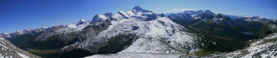
Above: Scale is impossible to judge up here and photos are just as bad. Randy starts to get smaller as we climb up “The Onion.” Incredible weather with a rare clear sky allowed us to see many peaks and routes hidden to us on past trips.
Above: At the top with an amazing view west towards Mt Collie and the Yoho exit. The mountain just over my head is Mt Collie and Mt McArthur. Without reference points, they appear close but they are 15 kilometers away! Had plenty of slapstick moments trying to use the self timer on the camera as I couldn’t move very quickly in my AT boots. Behind us, the spire of Mt St Nick (out of frame on the left) casts a shadow on the icefield several kilometers long!
Above: Telephoto shot of distant Mt Collie named after Norman Collie, a mountain climbing pioneer who did many first ascents and was the first to explore the Columbia Icefields and climb its highest peaks. I recently read his journal and he quickly became a much respected person to me so I really enjoyed finally seeing the mountain named after him. I was glad to see that his name is lent to such a stunning peak. On the wide open blank canvass of the icefield, it attacks the sky and declares itself with not a single rival to compare itself to.
Above: We pulled out the map and took advantage of the cloudless sky and 360 degree view to identify every peak and route through this area. From this vantage we even saw an easier way to get to Mt Gordon, our intended peak. Oh well, next time. After making some future plans it was time to go. Places like this are hard to get to and even harder to leave! At least we could look forward to a long ski run of 3000 vertical feet under a bluebird sky.
Above: Enjoying a nice long ski down with nothing but our own tracks for miles. Skiing with a big pack and harness isn’t easy but you get used to it. I got a chuckle from this picture as the extra gloves in my pockets make me look like I have a big gut.
A great trip with plenty of surprises. Considering we didn’t think we would even get into the back country any time soon due to dangerous avalanche conditions, this trip seemed like wining the lottery.


Glad you made it out. It’s nice to know that all the snow fort digging work I put the girls through will come in handy should they ever move to the mountains 😉
Vistas are fantastic, but it’s a shame that there isn’t more opportunity for picture taking when you suffer one of your rare slips at the end of a rope. That would probably cure a lot of people of the desire to climb.