I thought I would throw down a shotgun spatter of fall activities.
Above: A smokey view from Mt Cory. After crawling out of the bush my first thing was to make a return to Mt Cory. I had tried this one very early in my mountain endeavors and couldn’t find the correct ascent rib and got cliffed out. It was a small victory then to discover now how simple it seemed! Mostly an unpleasant climb and the heavy smoke from forest fires was a huge disincentive to keep going. A summit without a view is rarely worth it for me. In retrospect, this picture is kind of interesting with some unusual and subtle shades.

Above: Mt Lady MacDonald is a regular climb a couple times a season. An evening thunderstorm gave it a volcanic quality on this day. Suz and I brought sushi up for a mountaintop supper.

Above: Boom Lake. I’ve been trying to visit as many neglected lakes as I can. I combined this with a climb attempt of Mt Bell which rises off its flank. A very steep gully tested the nerves a little but most surprising was a visit from a hummingbird high up at treeline. I have never seen one in the Bow Valley before and this was not a place I expected to find one. It was hovering around some dying flowers in an old avalanche chute. I ended up not getting to the summit block but fine views were a good reward.

Above: Marc takes in the view on Frisby Ridge outside of Revelstoke. Suz and regular ski touring partners Hugo and Marc, and myself checked out this famous mountain bike trail in Revelstoke.

The trail is a real epic as it climbs over 2700 feet then follows the spine of a ridge with incredible views on each side. After a tough climb and fine rewards of a setting sun, we got to experience the thrill of the nearly 3000 foot descent back down the trail at breakneck speeds through twists and turns, big trees, rocks and rivers, and white knuckles! No without merit is this considered one of the premier trails in North America. We had a late supper in Revelstoke at 10pm and drove through the night getting back to Banff at 2am. 
Above: September surprised us with an early snowfall. My traditional first snowfall hike is to hike up to Grassi Lakes with my camera. Even with a blanket of white, the lake retains its rich hues of green and blue. This spiderweb was a great discovery at the lower lake. After taking a hundred pictures of the same things I take pictures of from the previous years, I stop in at Larwence Grassi’s memorial plaque and read the inscription. “Master Trailmaker, He sought new paths, made rough places smooth, pointed the way to higher levels and loftier achievements.” 

Above: I make an annual trip up the Mt Fairview’s summit. Usually I wait until the larches turn but I thought this year for a change I would see it green rather than orange. I picked a good high pressure day with clear blue sky. It’s one of my favorite spots in the Rockies as is evident from the large picture in our livingroom I took from this location. I couldn’t help but keep an eye on the time as I went up and noticed I could set a speed record if I picked up the pace. My only intention that day was to look at beautiful things but ended up sweating and gasping getting caught up in setting a best time! A grizzly bear on the way down gave the descent some interest.

Above: If the Mt Temple area is my favorite of the Rockies, this spot has to be my favorite in Kananaskis. Suz and I climbed up King Creek Ridge to get this stunning view of Mt Blane. We bashed our way up a steep, pathless slope and were greeted at the top by a heard of mountain sheep grazing peacefully. After drinking in the astounding views and taking too many pictures, we descended a pretty intimidating gully that was obviously the only way down into the next valley. Gorgeous alpine isolation but prime grizzly habitat had us keeping our wits about us. The exit was through the bottom of the King Creek Canyon, a Utah-like slot canyon that was a bit of a problem picking our way through the rapids, boulders and canyon walls. A great adventure into some stunning and seldom visited valleys. Below, Suz tops out on the ridge above the road before dropping into the next valley.

Above: Clouds lend an ethereal quality to the otherwise raw front range mountains. When a very old friend texted me that she was stopping in to Canmore, it didn’t take much convincing to get her to stay an extra day and climb a mountain. I suggested the Wintower as it’s close to Canmore with good views and not too stressful. Roberta is from Winnepeg and is in good shape for such flat country but started off so fast from the road she was amazed at how tired she was after a half hour. It was a reminder of how long it took me to learn how to correctly pace myself on big climbs. I explained she probably wasn’t in as bad of shape as she thought but just had to slow down for such a long haul. Self reproach and vows to spend more time on her bike was quickly replaced with “wows” as we neared the top. It’s so enjoyable to take people up to places like this as I get to appreciate them with new eyes.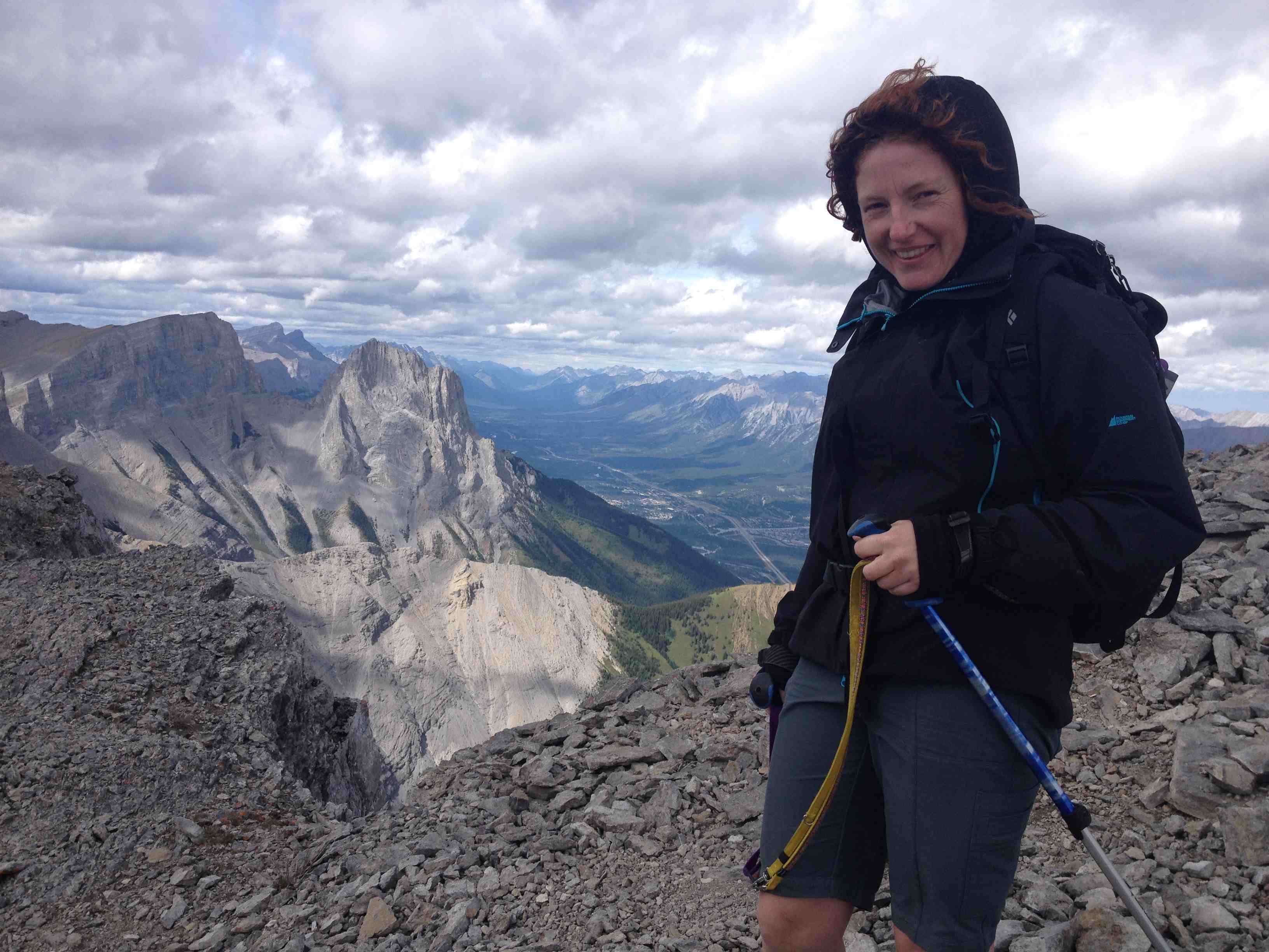

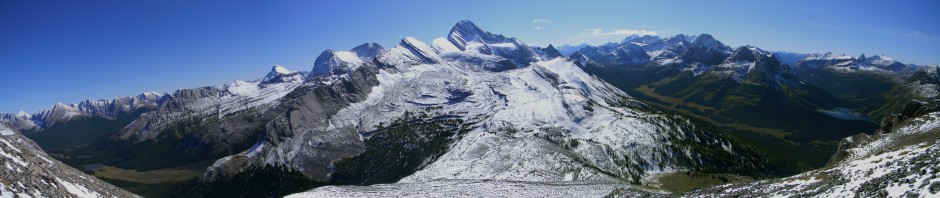
Above: The Mt Chester area is always closed for Grizzly bears when I want to go there. On this day though, I got lucky and had a perfect day climbing up past the lake and up Fortress Peak. I’ve been to the Chester/Fortess Col before with lots of snow but was ill equipped to scale the very steep and snowy headwall. This time, I brought an ice axe and clawed my way to the top with a few pauses to collect my nerves. On the horizon is the Burstall Pass area which is a favorite spot for ski touring. From this vantage point is an incredible amount of space. Mt Chester in the middle takes on a volcanic quality as it seems so isolated from this unique vantage point.
Above: Suz and I finally checked out Goat Glacier, the closest glacier to Canmore. It’s a mere 5km away from town but kind of hidden and not that easy to get at. You can’t see it from any road or trail so it’s often out of mind. It’s really just a remnant glacier as it’s so low in elevation, most of it melted a thousand years ago though it’s left quite a trough of destruction which is quite raw and interesting. The larches were in their most golden prime which was a nice surprise.

Above: In order to visit the Lake Ohara region, you must book a spot on the shuttle bus that takes you up from the highway. Parks Canada controls the number of visitors through the limited shuttlebus. However, you are free to hike up the 13km road that gains a few thousand feet in elevation. I gave myself the challenge of running up the road, then running up the additional thousand feet and 10km trail to Lake McCarthur, taking some pictures then running all the way back down! It was quite a grind but all worth it as the lake is the finest I have ever seen. The picture above I think can back up what otherwise would be quite the claim. The lake is very, very deep which gives it a cerulean colour unseen anywhere. Added to this were some scattered larches still clinging to some firey colour. This really is a place to see slowly over a week, not in a crazy up and down epic but being an international destination, the shuttle bus is booked months in advance. For the dual quality of being astounding as well as the satisfaction of accomplishment, this really was the trip of the year.
The run up was filled with incredible beauty that deserved more time than I could give it. Next year I think Suz and I will try to get up here for a few days. We ski up here in the winter but summer is when the place is at its best. This trip also opened my eyes to the possibility of accessing distant places in a single day. I’m starting to exhaust many of the peaks and valleys within an easy drive of home. When I look for new places on the map, I find that they all involve multi-day efforts. With continued improvement, this trip seemed like finding a cheat card to get to all those far flung places in single day efforts. For next year, I already have a single day trip planned to Mt Assiniboine which is usually hiked in 3 days.

Above: Suz and I followed in the footsteps of a wolf pack on its way over the high pass at Shadow Lake. This year we decided to go “larching” in a new location. The larches can only be found at the highest elevations of the tree line so it’s always an adventure finding new locations. This year we went to often ignored Gibbon Pass. The approach involves a 12km mountain bike climb and then a substantial climb up a steep slope to get to a high alpine meadow. A cold and wind snap had left the larches less than perfect but it was an enjoyable trip with many surprises. The plateau above Gibbon Pass was a wild place. The remaining needles were mostly on the lower branched making it appear as those the ground was engulfed in fire.

The other side of the plateau drops down to Twin and Arnica Lakes via this needle encrusted trail. A “Wizard of Oz” quality makes this path hard not to follow. After running out of daytime, we made our way back to our bikes and prepared for the long, fast downhill run back to the road. Suz had been previewing many film entries to the Banff Mountain Film Festival and I think the biking films had some effect on her as I couldn’t believe how fast she was going down the slope! I ended up pushing my comfort level a bit to keep her occasionally in my sights as we bombed the run down through rocks and streams.
A fine September! I didn’t get up any 11,000ers which had been a goal of mine. Couldn’t organize with a climbing partner to tackle any of them during the proper weather but enjoyed smaller scale adventures just as much.


Wow! Congrats on the 46km round trip run at Lake O’Hara! That’s a tougher marathon run than most! Discovering how with a bit of training and running the flatter sections, its really like adding hours to the day! My mountain running is pretty much confined to hill repeats in the North Saskatchewan River valley but its not hard to tick off 1200 feet in a good lunchtime run. So when I am in the mountains on a run, a flat or gentle hill is actually a treat!
Must correct the distance, I seem to have written it poorly as it was “only” 32 km. Yes just the right incline is ideal. I’m amazed at how an extra few degrees can stop me dead when just a few less is unnoticed. I do have a marathon+ distance picked out for next year going all the way around Mt Rundle. I did half the other day (23km) and the whole thing seemed reachable by next year.