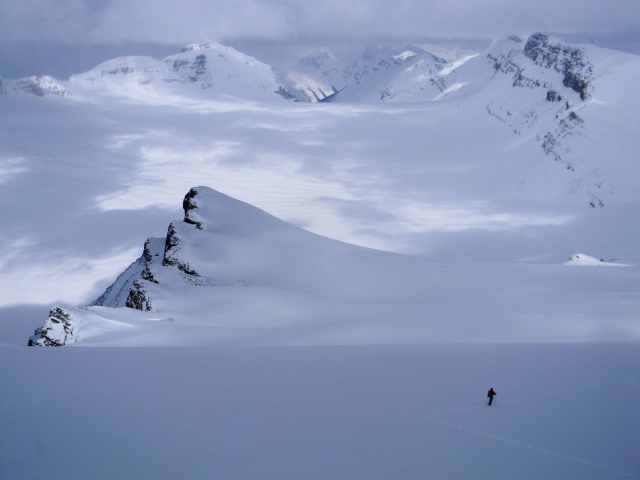
Of the many books by my bedside, Summits and Icefields by Chic Scott is one that I often flip through when I can’t sleep. One of the pictures I always flip to is on page 126 with a view from Mt Gordon down across the Ayesha Icefield. “Some day I’ll see that view for myself,” I’ve thought many times before falling asleep. I’ve tried once before only to be thwarted by bad weather so it was time to mount another attempt.
This trip was with my usual mountain adventure partner Randy and new friend Ryan. Ryan is a very accomplished rock climber in the Bow Valley but with less big mountain and glacier experience. He would also be dependant on us for avalanche safety though he had some training in companion rescue. Just as important though was his enthusiasm and energy.
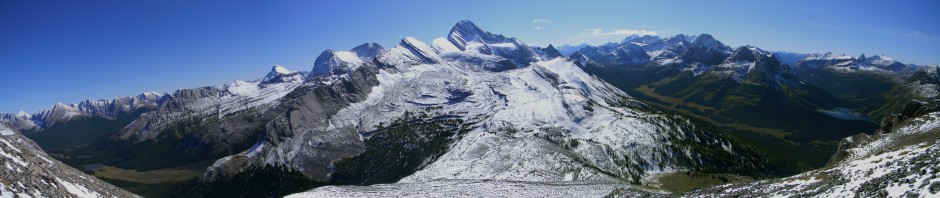
 Above: Mt Gordon is located on the Continental Divide on the Wapta Icefields. It sits between the Yoho valley and the upper reaches of the Bow Valley. We left very early morning and after a lengthy climb we emerged above treeline and up onto the Bow Glacier. The weather was not looking very promising but we decided to climb up to the foot of Mt Gordon and if the weather improved we would be position to make an attempt.
Above: After a few more hours of climbing the weather did not seem to improve. I brought a mapping gps unit to make whiteout navigation easier but it doesn’t help you find the will to put one foot blindly in front of the other. We took a more northern line across this part of the glacier as last year we were trapped by a crevasse system around the same spot. 
Above: Using my avalanche probe, I’m showing Ryan how to check the depth and strength of the crevasse bridges. As we change aspect on the massive glacier, the depth of snow changes due to wind transport effects. Keeping a close eye on that gives us a heads up on when we should start travelling roped up.
Above: Time to rope up to protect against falling through the snow into a crevasse. Mt Olive breaks through the fog in the background.
We pressed on through the afternoon climbing the lower flank of Mt Gordon but the thought of working so hard to have no view was not very uplifting. Randy hit the wall on lead as we started to climb Gordon. I know him pretty well and it took me only a few minutes to notice he was stopping exactly every hundred steps so I knew he was already into higher level coping strategies! I shouted up through the blizzard “Need me to take the next hundred?!” Randy didn’t even blink that I knew what he had been doing and just yelled back he couldn’t lead any more.
We swapped lead and I carried on up the mountain. It’s so hard to describe how much energy it takes to lead through blind nothingness. It really puts a sharp focus on what uncertainty can do to you. Climbing in a whiteout is about as uncertain experience as you can get when you can’t easily tell what is sky what is ground and what is the abyss. When I took the lead I was trying to feel the tension on the rope as I didn’t want to move faster than those following due to their exhaustion. It’s uncomfortable for all to be pulled and yanked when connected on the rope. But the rope was perfectly tensioned so Randy’s tiredness had just evaporated when he only had to follow behind. 
We made our way up and onto the final ramp to the summit. A wall of snow and ice seemed to be facing us where an easy ramp was supposed to be. We were now on the summit ridge and a huge, thousand foot cliff down into the Yoho Valley was unseen in the fog a few meters to our right. I stopped for some water and sugar and the whiteout intensified. I didn’t think it was safe to continue under the conditions and for no better payoff than being able to say we were at the top. I called Ryan and Randy up and we had a conference about our options. We waited a bit but a blizzard at 10,300 feet is not a very pleasant place to wait! We all agreed that we had to turn around under the conditions. After ten thousand feet, we were just a hundred meters from the top!
We made a retreat back down and stayed at the Bow Hut for the night. There was a couple mountaineering guides staying at the hut so the conversation was interesting as we flattened the maps out and quizzed them on different routes and trips. We ate well and went to sleep at 9pm after a pretty big day. Day 2 might bring better weather.

Above: We awoke early and packed up excited that the skies had cleared giving us great visibility. We would make another attempt on Mt Gordon. Mt Jimmy Simpson makes a great backdrop as we climb the Bow Glacier again. I just love these remote, high mountain locations.
Above: With good visibility and no wind, we make easy work of the climb to Mt Gordon. The only thing slowing us down is the awe inspiring views. The picture above shows us climbing up the confluence of the Yoho, Ayesha and Bow glaciers. Behind Randy is Mt Rhondda which is next on our list for it’s monster ski descents available. Ten thousand foot high mountains of the Continental Divide march northward. We returned to the wall where we turned around the day before. Randy had the awkward job of climbing over it blind. I kept thinking it was a corniced drop off he was scaling and was ready for him to fall off the end ( we’re roped of course but no less unnerving.) But the top of the wall was a flat platform that marked the spacious summit. We hiked along the precipice to gain an extra few meters to be at the true summit. From the top you can see the entire Wapta traverse, the whole Yoho Valley including the Iceline trail. 
Above: After a few failures finally success! From the summit of Mt Gordon looking south towards Mt Balfour with the Yoho valley on far right. This is the highest mountain around so we spent some time identifying peaks before putting on our skis in anticipation of a massive downhill run through untracked powder.
Above: Making a plan for skiing down the massive mountain Randy checks out a line he’s interested in. 
Above: The views on the way down defy description. Difficult to get to. Even harder to leave.
And Below! On the descent, I make my own copy of the picture from “Summits and Icefields” that inspired me to work so hard to get here! I didn’t get Ryan in the exact location as the figure in the original and it didn’t seem fair to make him climb up and over to the left just for my picture project! I can only say that in spite of drooling over the original photo, this spot was even better than I could have imagined. A profound vantage point.

We drank it all in as we skied down thousands of feet of powder. We stopped at the hut to pick up our supplies and met Barry Blanchard who was just coming off a different mountain. He’s a mountaineering legend and one of the best in the world with many first ascents and popular books. I would have liked to have chatted with him but exhaustion and the need to get back to the highway allowed only quick greetings.
It was a wonderful trip and we felt our good weather was earned given our struggles the previous day. We crossed one place off our list but added a few more while gazing out from the summit!


Well done on all counts. Your presence of mind to grab that photo is comendable. It will be a nice homage for your (inevitable) book.
Like New York Changing! You could revisit famous mountaineering photos decades later.