One of the motivations for ultramarathon training was to be able to do big objectives in the mountains. With snow on the way and fine autumn conditions soon to fade, I wanted to put my training to the test in the wild. Even though I wasn’t fully recovered, my window was closing quick so I planned a one day traverse along the continental divide from the Sunshine parking lot to Mt Shark trailhead in Kananaskis. The route was 60kms over 3 mountain passes past 9 lakes and over 12,000 feet of elevation gain and loss.
What makes this route a bit scary at this time of year is the isolation. There is a point along the route where you are 30kms from the hi-way whether you go forwards or backwards. At no point on the route is there cellphone service. Unlike an organized race where you can quit any time and be taken care of, I would have to make some serious and objective self assessments before the point of no return to be sure I could finish. Going this far means going fast and light so no tent or sleeping bag. Given that the night time temperature is below zero, you have to be sure you can finish! For safety, I brought my SPOT locator beacon so I could be tracked down in an emergency. 
Above: The hiking book suggests this route be done as 3-6 day backpacking trip. This was what I brought: headlamp, SPOT emergency beacon, bear bangers for possible bear problem, nutritional gels, map, emergency heat reflective bivy sac, water bottle and poles. Not pictured was my ultra-lightweight Mammut puffy jacket which was for emergency but only weighs a few hundred grams.
My plan was to leave at 5am but the night before I couldn’t sleep at all. The whole enterprise was very stressful. When 5am rolled around I felt hardly fit for such a trip but knowing I wouldn’t get another chance this year, I went ahead. Suz was going to meet me on the Smith Dorian road at 8pm. She would be getting hourly position updates from me by satellite so she would know if I was close before making the hour drive from Canmore. Of course once she leaves Canmore, she can no longer get the position updates as they require a mobile connection.
At 5:40am I arrived by car at the end of the Sunshine road just off the Trans-Canada. In blackness I put on my light trail shoes, turned on the headlamp and started up underneath the Sunshine Gondola. I don’t like the dark in the mountains! I made lots of noise and had my head on a swivel. My first objective was a 12km climb gaining 3000 vertical feet up to Citadel Pass. The adrenaline of climbing in the dark made me go much too fast and I topped out in just over 2 hours. A streaking shooting star burnt up overhead leaving a red blaze imprinted on my eyes. I took it as a good omen!
Above: Dawn in the middle of nowhere! It was psychologically relieving to be able to see the lay of the land and turn off the headlamp and stow it away. When planning at home, I had been slightly worried about navigating by headlamp for the first few hours but it had all gone smoothly. Hopefully I wouldn’t need it much at the tail end of the trip! Crossing over Citadel Pass as the sun rose to warm the frigid air and light the way was a double dose of goodness.
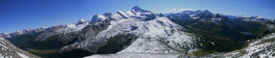
I had never been here before and seeing it by dawn light was amazing but frustrating to not be able to stop and gawk at the sights. From here out, most of the trip was in and out of the tree line. Everywhere seemed like good Grizzly habitat and I shouted every few minutes. 
Above: Down into the next valley system, the Golden Valley. Mt Assiniboine just peaks out on the left skyline.
The trail follows a high traverse along Golden Valley and on a narrow ledge, I stopped for some sugar and a physical assessment. I was now 20km into the trip so if I was not going to make it, I’d have to turn around soon. Already facing a 20km return to the road or a 40km forward seemed like two devilish options! I was tired from lack of sleep but I thought I would go forward and commit to the big distance. The 20k home seems worse because you already can imagine what it will be like. The way forward has the benefit of being unknown. For some reason the known seemed worse than the unknown which is rare in the wilderness.
The trail wound its way through a series of lakes and rocky hollows and into a valley called “The Valley of the Rocks.” An amazing landscape formed from giant blocks of quartzite from an ancient catastrophic landslide.
Above: Valley of the Rocks. Getting closer to Mt Assiniboine which makes a dramatic half way point.
The weather was a sunny 9 degrees which is perfect for hard work. Unfortunately the warmth was melting the trail now. Repeated freezing and thawing was growing tall ice crystals under the surface of the trail.
Above: Some of the ice crystals were over an inch tall which elevated the muddy surface up. Now that the sun hit it, your weight would cause the crystals to collapse making footing problematic and slippery. As you can see, my hands are muddy from repeated falls! There was about 8kms of this sticky, moving mud and ice shards to deal with. Unexpected and exhausting!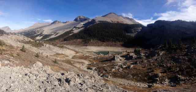
Above: The strange environs of Og lake. Random crags and features are as odd as it’s name. Previous stop along the way, Citadel Pass, is just seen in distance at far left skyline.
Above: Mt Assiniboine and Lake. Luxuriously alone here as the seasonal backcountry lodge attracts many people when in season. In fact, I hadn’t seen a single person so far. A wonderful sight and hard to leave but now every step was getting me closer not further away. The time was just after 1pm and it seemed like I was making good progress and wouldn’t have too much night navigation to do at the tail end.
Above: Climbed up Wonder Pass into a gorgeous larch forest with all its orange needles littering the ground. One of the best named passes! Upon getting to the top, the also well-named Marvel Lake appeared in translucent blue. An amazing sight but when you are exhausted, it lifts the spirit like nothing else to see such beauty.

Above: Down the other side of Wonder Pass halfway across a high-level traverse of Marvel Lake. Ten more kilometers and I’d be in the Bryant Creek drainage which was the last valley system.
As my familiar landmarks appeared that signalled getting close, I found the aches and pains began to get far worse. The mind loses its ability to cope when it knows things are drawing to an end. When I finally reached the Bryant Creek trail which I had been on before, I found my knee starting to kill me as well as ankle pain flaring up. After 7 more kms I was crossing the Spray River as it poured into Spray Lake. The last hints of daylight had left and my headlamp was back on. The only thing left was 6 kms of ski trails to navigate by headlamp. By now I was hobbling a bit but the end was close enough now. My whoop was heard by no one at the road and success was overshadowed by relief it was over. I hunkered down to keep warm waiting for Suz to pick me up and after a very lonely 40 minutes, headlights finally appeared to my deep relief!
A good trip to end the year on. I learned not to do a trip like this on anything but full strength! I’m paying the price today as I hobble around like a cripple. The intensely committing nature of this trip was exciting but the lack of margin for error was more stressful than exciting. As it should be. I like to be in the wilds prepared for any contingency. Going this fast and light can’t accommodate those preparations very well so I must find a way to reach a better middle ground in future mega distance plans.
And now I will recover while I get excited for next week’s Banff Mountain Film Festival!

